
Observations and Modeling to Advance a Louisiana Coastal Circulation and Oil Spill Prediction System

The BP Gulf Research Initiative is a collaboration between faculty and staff of LSU's School of the Coast and Environment, LSU Center for Computation and Technology (CCT) and the Naval Research Laboratory, Stennis (NRL) tasked with enhancing the state of Louisiana's ability to observe and model near-coastal circulation along the Louisiana coast for use within the state's broader oil spill prediction system. The project is comprised of four main components:
- Simulation modeling will couple Finite Volume Coastal Ocean Module (FVCOM) bay modules to an enhanced FVCOM shelf module with offshore conditions provided by NRL's operational Intra-Americas Sea Nowcast/Forecast System for analysis of oil dispersion hind-casting.
- Wave-Current-Surge Information System (WAVCIS) information with be leveraged for validating component 1. WAVCIS is a real-time regional coastal observation system that operates six shelf stations to measure winds, waves, currents, temperature and salinity.
- The Earth Scan Laboratory (ESL) will provide surface oil areal estimates for validation of component 1. ESL capabilities were enhanced in 2014 to receive and process VIIRS measurements in near real-time.
- Provide integrated visualization capability for viewing, analyzing, and communicating results from model simulations and model-data integration intended for use by coastal resource managers and decision makers.
See the ESL image and oil contour archive in support of this project here

Shelf and Bay Model - Dubravko Justic (Co-PI), Haosheng Huang (Co-PI), and Lixia Wang (Research Associate IV), Dept of
Oceanography and Coastal Sciences, School of the Coast and Environment
Boundary Conditions - Dong Ko (Naval Research Lab, Stennis Space Center, Stennis, MS)
The shelf sub-module, based on the Finite Volume Coastal Ocean Model (FVCOM), will simulate the hydrodynamics that will fundamentally describe physical  processes controlling the transport of surface oil from the shelf to the
shoreline. It will be coupled to the Naval Research Laboratory's Intra-Americas Sea regional model (IASNFS) (Ko et al., 2003, 2008). The bay sub-module employs a higher resolution
FVCOM, and will resolve finer-scale surface processes, including the inundation of wetlands, to determine the fate of oil in shoreline environments. The coupling module provides the mechanism with which to dynamically couple the IASNFS with the shelf sub-module, and how to couple the shelf sub-module with the bay sub-module. Stand-alone FVCOM results will be quantitatively evaluated against several
independent series of observations provided by the Earth Scan Lab (ESL) and the Wave-Current-Surge Information System (WAVCIS) that include tidal gauge data,
processes controlling the transport of surface oil from the shelf to the
shoreline. It will be coupled to the Naval Research Laboratory's Intra-Americas Sea regional model (IASNFS) (Ko et al., 2003, 2008). The bay sub-module employs a higher resolution
FVCOM, and will resolve finer-scale surface processes, including the inundation of wetlands, to determine the fate of oil in shoreline environments. The coupling module provides the mechanism with which to dynamically couple the IASNFS with the shelf sub-module, and how to couple the shelf sub-module with the bay sub-module. Stand-alone FVCOM results will be quantitatively evaluated against several
independent series of observations provided by the Earth Scan Lab (ESL) and the Wave-Current-Surge Information System (WAVCIS) that include tidal gauge data,  Acoustic Doppler Current Profiler (ADCP) data, shipboard measurements of temperature and
salinity, and satellite imagery of sea surface temperature, sea surface height and oil slick features. This nesting capability represents one of the most challenging issues in numerical ocean modeling to study the transport and fate of
oil in a coastal environment. A surface slick-weathering module for evaporation and dissolution will be provided. The primary objective of this effort is to develop a coupled observation-hindcasting-forecasting system for the northern
Gulf of Mexico (GoM) to replicate and predict the amount of oil arriving, its weathering extent, and the movement on the surface of oil from off shore to environments of a deltaic coast including barrier islands, bays, estuaries and
shoreline wetlands. This model framework can also be used by federal and state agencies in contingency planning and emergency decision making in future accidents of oil spill, contaminant pollution, or other natural or anthropological
disasters.
Acoustic Doppler Current Profiler (ADCP) data, shipboard measurements of temperature and
salinity, and satellite imagery of sea surface temperature, sea surface height and oil slick features. This nesting capability represents one of the most challenging issues in numerical ocean modeling to study the transport and fate of
oil in a coastal environment. A surface slick-weathering module for evaporation and dissolution will be provided. The primary objective of this effort is to develop a coupled observation-hindcasting-forecasting system for the northern
Gulf of Mexico (GoM) to replicate and predict the amount of oil arriving, its weathering extent, and the movement on the surface of oil from off shore to environments of a deltaic coast including barrier islands, bays, estuaries and
shoreline wetlands. This model framework can also be used by federal and state agencies in contingency planning and emergency decision making in future accidents of oil spill, contaminant pollution, or other natural or anthropological
disasters.
Sea Oil Budget and Weathering - Louis Joseph Thibodeaux (Co-PI), Christopher Stevens, Ta' Ryan Lloyd, Jessica Owens, Katrina Rickels, Steven Nguyen, David Galin, Nicholas Klinka, and Kal Gungslinger, Cain Dept. of Chemical Engineering, College of Engineering
Whether oil is released at the surface or from deepwater well blowouts, sea surface slicks are always a consequence of oil spills. Chemical dispersants are used in reducing the size of slicks and the ensuing environmental impact of oil on
the water column, shoreline, estuaries, etc. (Coolbaugh and Clarke, 2010; NRC, 2005). However, a large fraction of the oil can remain at depth in "dispersed" form either deposited on the bottom or retained in the water column (Thibodeaux
et al., 2010a). The issue of oil sinking and depositing on the seabed is controversial (Thibodeaux et al., 2010b), but passive depositional transport of tiny droplets and solutes must be considered. Once formed, the tiny particles move
horizontally by shelf water currents and are dispersed. Fluid dynamic driven vertical particle transport occurs as well, however its flux rate is slowed dramatically by thermal and salinity stratification (Thibodeaux and Lohmann, 2011). A
subsurface oil movement and deposition model is essential for simulation of oil in deltaic coast waters. The objectives of this modeling sub-element are: 1) develop appropriate chemo-dynamic process algorithms to quantify oil settling
(Thibodeaux, et al., 2010 a,b) and in-column "plume" formation with and without dispersants and, 2) couple these plus the other standard weathering processes onto an appropriate hydrodynamic framework such as FVCOM.
The model development approach will be to build upon the NOAA Automated Data Inquiry for Oil Spills model (ADIOS2). ADIOS2 uses mathematical equations and database information to predict: 1) changes in density, viscosity, and water
content of an oil or product over time; 2) rates of evaporation from the sea surface and dispersion into the water; and 3) the rate at which an oil-in-water emulsion may form. It uses information that can quickly be estimated or obtained
in the field, such as wind speed, wave height, water T/S, the type and amount of oil, and the rate and duration of the spill. For the new processes, a reactive, advective and diffusive continuity equation/mass balance first principle
approach will be used (Thibodeaux, 1996). The object of formulation is to create the theoretical structure and algorithms for including these processes into the appropriate hydrodynamic model (FVCOM). FVCOM will be assessed for its
ability to provide in-column fluid dynamics, related turbulent transport characteristics and pycnocline stability. These processes are necessary for modeling near surface oil, droplet dispersion, soluble fraction degradation, deposition
on the sea bed surface, evaporation, dissolution, and fate and transport processes. An assessment is also needed for available oil data, both water column and seabed, that can accompany the modeling effort and is also relevant to the
on-shelf processes.
Earth Scan Laboratory - Nan Walker (PI), Alaric Haag, Chet Pilley, Ambrose Bordelon, and Jordan Pino, Dept of Oceanography and Coastal Sciences and Coastal Studies Institute, School of the Coast and Environment


In support of this project the Earth Scan Laboratory will provide the modeling component with the best available satellite imagery of the distribution of surface oil during the DWH oil event, initiate new integration products in
collaboration with WAVCIS, and perform research on the usefulness of satellite products for accurate oil mapping.
MODIS and SAR image products will be provided to the numerical modelers and visualization experts. An existing archive of oil spill images will be used
extensively. The oil features apparent in these images will be digitized and time-series of the oil will be provided. Additional data may prove beneficial for revealing circulation processes including the night-time SST composites from
GOES, MODIS "true color" images revealing river plumes and fronts, and ocean color images (chlorophyll a). Image animations will be produced to assist in tracking oil and circulation changes. A research element is proposed whereby
comparative analyses of various image products (visible band, infrared, and SAR) will be undertaken using near-simultaneous acquisitions. The ESL staff will obtain WAVCIS current and wind data and superimpose these on ESL satellite data
to enhance potential usefulness of both data types. In addition, new products will be added to the ESL oil spill archive as they become available.
Visualization - Werner Benger (co-PI), Neha Manya and Isaac Ayyala, Center for Computation and Technology
We will provide an integrated visualization of the data sets produced by this project, i.e. data stemming from computational modeling, WAVCIS and ESL observations. The diversity of these data sets, both with respect to their
spatiotemporal as well as topological properties, requires special attention in their data management in order to allow fusing them into one common visualization environment. Incompatibility of data formats and data models is a well-known
problem (Benger, 2009b), which we will address through utilizing a common denominator based on the widely used HDF5 file format.
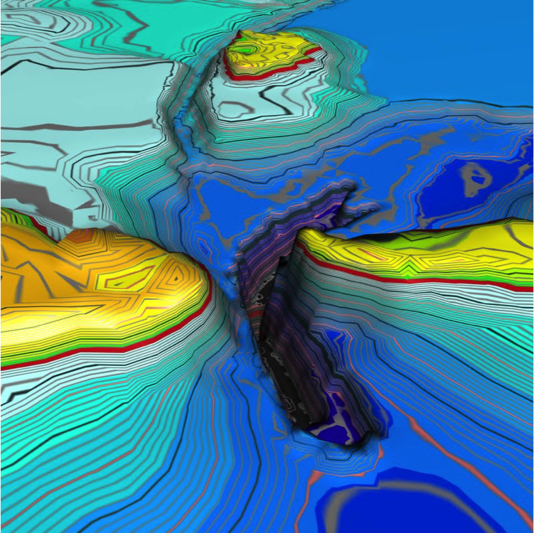
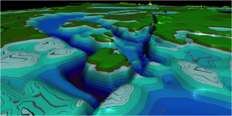
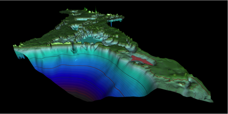
Data from oil-water simulations are three dimensional (3D) and time dependent in nature, described mathematically primarily via scalar and vector fields. We plan to adapt and expand visualization methods developed for computational fluid
dynamics (Benger et al., 2009a; Bohara et al., 2010a, 2010b) and preliminary 3D oil spill simulations (Bohara et al., 2010c). In particular we intend to investigate mixing indicators of oil and water, such as curvature and torsion of
particle trajectories (Benger and Ritter, 2010; Bohara et al., 2010b), as well as to apply tensor field analysis techniques (Benger and Hege, 2006) to study the properties of derived quantities, such as dissipation of the immersed oil
particles or critical points (sinks, sources, vortices) in the ocean flow. The simulation data will be processed further to identify indicators for the mixing of oil and water during weathering of the oil in the GoM. The proposed
integrated visualization will display time-dependent scalar and vector values given at a specific point on the ocean surface as part of a three-dimensional model of the GoM as provided by the FVCOM nested triangular grid, overlaid with
satellite imagery from ESL and simulation data from IASNFS structured grids.
Wave-Current-Surge Information System (WAVCIS) - Chunyan Li (co-PI), Baozhu Liu, Bill Gibson, Yixin Luo, and Mohammad Nabi Allahdadi, Dept of Oceanography and Coastal Sciences and Coastal Studies Institute, School of the Coast and Environment
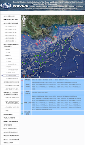
WAVCIS was established by Dr. Greg Stone and became operational in 1998. It provides real-time hydrodynamic information (water level, flow velocity), wave information (wave height, direction, frequency, period), hydrographic information
(water temperature, salinity, density) and meteorological conditions (wind direction and magnitude, air pressure, air temperature and humidity) along the Louisiana coast. WAVCIS provides daily forecasts of wave and flow conditions in the
GoM using industry standard and state-of-the-art three-dimensional fully nonlinear primitive equation numerical models. WAVCIS also provides the only in-situ data along the Louisiana continental shelf to serve emergency response
activities during many types of marine events such as hurricanes, oil spills, floods, and search/rescue efforts.
Currently there are six WAVCIS stations, all of which are located on offshore oil platforms owned by private oil and gas companies (Fig. 1). WAVCIS instrumentation suffered during the DWH event in 2010, due to the difficulty in diving,
that resulted in reduced maintenance for many months. We anticipate that all of the stations will be returned to operational status before the end of 2011. Data collected from these stations are transmitted through satellite modems or
phones to the WAVCIS lab at LSU where they undergo quality control, post-processing and archiving into an online database. All the WAVCIS data, graphics, and model predictions are automated and posted in near real-time on the World Wide
Web for all to use. The communication computer, the web server, and the processing computer are the main components of the system. These computers are becoming slow and need replacement to better serve data collection, automated data
processing, real-time reporting, and modeling needs. The software also needs updating to take advantage of new technology and web functions. In order to support the goal of this project and to reliably serve future potential emergency
management activities, we need to improve the infrastructure.
The main objectives of this component are to improve the function and reliability of the six existing WAVCIS stations to provide high quality, continuous, and real time information in support of the proposed numerical model forecasting
system, described in component 1. We will provide data during the oil spill event for model validation and will develop integration products in tandem with the ESL. We propose the following work and deliverables.
