Satellites
ABI
AVHRR
GVAR
MODIS
OCM
VIIRS
Satellite Schedule
Imagery
Archives
ABI
Nightly GOM SST
All Archives
Animate ABI
AVHRR
GCOOS SST
Atchafalaya Bay SST
Mississippi River Plume SST
Gulf of Mexico SST
Daily Swaths
All Archives
Animate AVHRR
GVAR
MONTHLY SST
GOM SST
North Atlantic Daily SST
EL NINO SST
WEEKLY SST
All Archives
Animate GVAR
MODIS
Louisiana Coast Truecolor
Deepwater Horizon
Regional Truecolor
All Archives
Animate MODIS
OCM
Chlorophyll
Truecolor
All Archives
Animate OCM
VIIRS
VIIRS Gulf of Mexico SST
All Archives
Animate VIIRS
Galleries
Atmospheric Imagery
Animator
Best of ESL
Hurricanes
Seasons
2019
2018
2017
2016
2015
2014
2013
2012
2011
2010
2009
2008
2007
2006
2005
2004
2003
2002
2001
Current Outlook and Discussion
Research
Projects
GCOOS SST
Loop Current and Eddy Circulation Studies
Louisiana Coastal Surveillance
High Resolution Coastal Flood Mapping
Hurricane Research
Deepwater Horizon Surface Oil Research
Observations and Modeling to Advance a Louisiana Coastal Circulation and Oil Spill Prediction System
Publications
Education
About
About the ESL
Contacts
News
Earth Scan Laboratory
Coastal Studies Institute
•
Department of Oceanography & Coastal Sciences
College of the Coast and Environment
•
Louisiana State University
Search:
For full functionality of this site it is necessary to enable JavaScript. Here are the
instructions how to enable JavaScript in your web browser
.
Latest Image of the Week
Jump to:
May-2023
January-2023
August-2022
June-2022
April-2022
January-2022
October-2021
March-2019
February-2019
September-2018
March-2018
December-2017
September-2017
August-2017
March-2017
October-2016
August-2016
July-2016
May-2016
April-2016
March-2016
February-2016
January-2016
December-2015
November-2015
October-2015
September-2015
August-2015
July-2015
June-2015
May-2015
April-2015
March-2015
February-2015
January-2015
December-2014
November-2014
October-2014
September-2014
August-2014
July-2014
June-2014
May-2014
April-2014
March-2014
February-2014
January-2014
December-2013
November-2013
October-2013
September-2013
August-2013
July-2013
June-2013
May-2013
April-2013
March-2013
February-2013
January-2013
December-2012
November-2012
October-2012
September-2012
July-2012
June-2012
May-2012
April-2012
March-2012
February-2012
January-2012
December-2011
November-2011
October-2011
September-2011
August-2011
July-2011
June-2011
May-2011
February-2011
January-2011
December-2010
October-2010
September-2010
August-2010
July-2010
June-2010
May-2010
April-2010
March-2010
August-2009
July-2009
June-2009
May-2009
March-2009
February-2009
January-2009
December-2008
November-2008
October-2008
September-2008
May-2008
January-2008
August-2007
July-2007
June-2007
May-2007
April-2007
March-2007
February-2007
January-2007
December-2006
November-2006
October-2006
September-2006
August-2006
July-2006
June-2006
May-2006
April-2006
August-2005
June-2005
May-2005
April-2005
September-2004
October-2002
August-1992
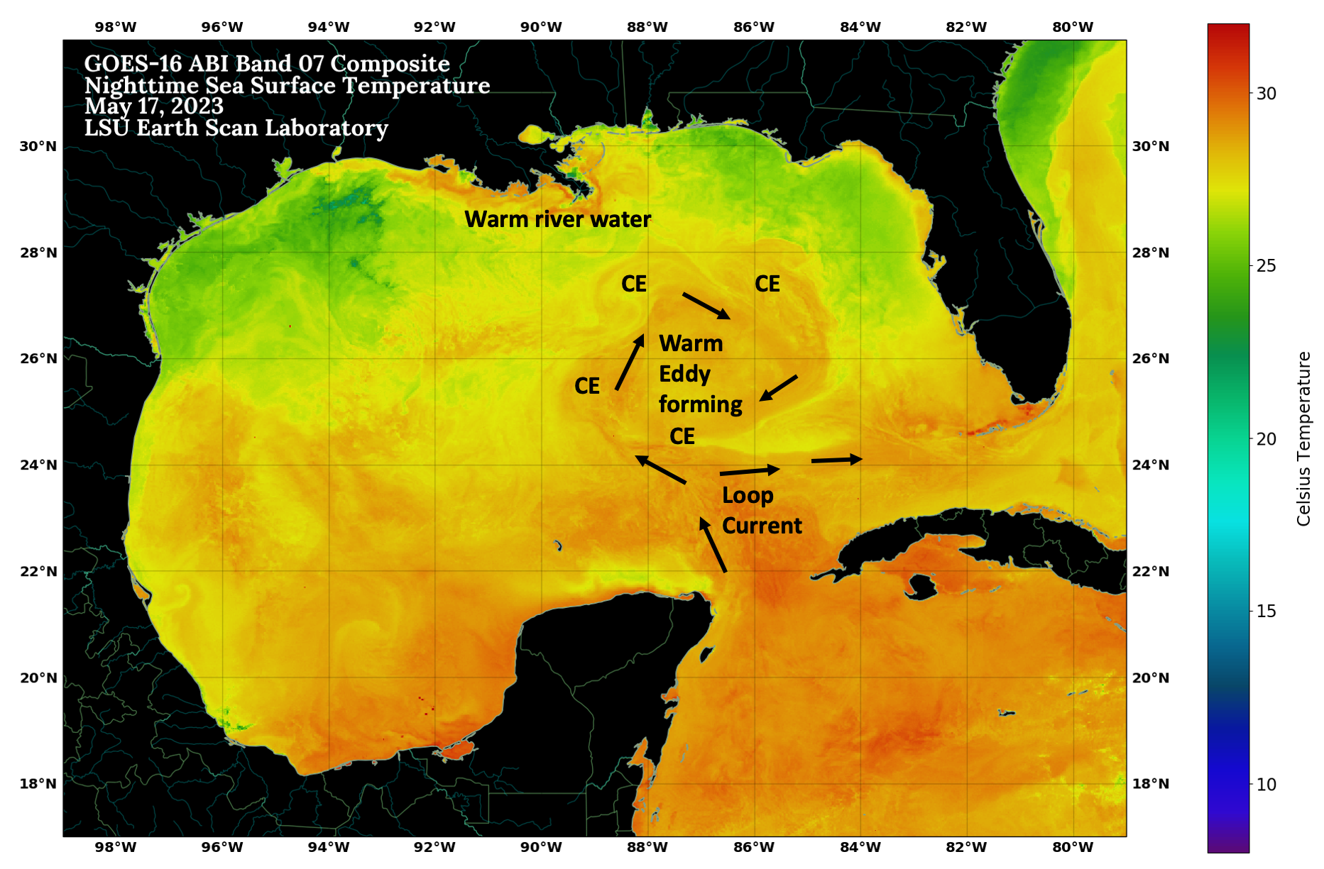
May 2023
ABI SST of Loop Current, May 2023
January 2023
Eddy Zodiac Formation
August 2022
Gulf of Mexico SST, August 16, 2022
June 2022
June 21 ABI SST Eddy
June 14, 2022 Loop Current
April 2022
April 25 GoM SST
January 2022
GOES-16 ABI Gulf of Mexico SST
October 2021
Aqua MODIS truecolor Gulf of Mexico
March 2019
Flood Sediment March 2019
Mar 06 2019 16:31 Landsat 30m Lake Pontchartrain
February 2019
Feb 11 2019 GOES-16 Full DIsk
September 2018
Sep 12 2018 MODIS Hurricane Florence
March 2018
Mar 03 2018 Landsat8 LakePont
December 2017
Dec 09 2017 19:35 MODIS AQUA Snow
September 2017
Sep 06 2017 MODIS 250m Irma
August 2017
Aug 20 2017 GOES GOM Color SST/SSH
March 2017
Mar 14 2017 19:25 MODIS 250m LA
October 2016
Landsat-8-true-color Oct 30 2016
Landsat-8 true color Oct 07 2016
August 2016
Record Rainfall Event, August 2016
Typhoon Nida
July 2016
Super Typhoon Nepartak
May 2016
May 2016 GOES Monthly North Atlantic SST Anomaly
May 04 2016 18:45 MODIS 250m LA
April 2016
Apr 2016 GOES Monthly North Atlantic SST Anomaly
Apr 03 2016 19:30 MODIS 250m LA
February 2016
Mar 01 2016 NOAA 7 Day Composite with SSH
Feb 26 2016 19:10 MODIS 250m LA
Feb 10 2016 19:10 MODIS 250m LA
January 2016
Winter Storm Jonas Snowfall
Modis True Color Image Lake Pontchartrain Jan 18
Modis True Color Lake Pontchartrain
Bonnet Carre Spillway Opening Effect
Jan 06 2016 18:40 MODIS 250m LA
December 2015
Dec 14 2015 17:00 MODIS 250m LA
November 2015
VIIRS Holiday 2015
MODIS Sediment
MODIS Mountain Snow
October 2015
Eddy Olympus GOES
Eddy Olympus
Hurricane Patricia's Eye
Hurricane Olaf
MODIS Image Clear Skies
Oct 12 2015 19:15 MODIS 250m LA
Oct 02 2015 17:05 MODIS 250m ATCH
September 2015
Sep 22 2015 16:30 MODIS 250m LA
Sep 13 2015 16:35 MODIS 250m LA
Typhoon Kilo
August 2015
Katrina Panel
Hurricane Katrina 10 year
Landsat8 Image
July 2015
Atchafalaya Sediment Discharge
Atchafalaya Basin Sediment
Typhoon Chan-Hom
Jul 04 2015 07:27 UTC VIIRS GOM M13 Temperature
June 2015
African Dust South America
Tropical Storm Bill
Mississippi River Plume
May 2015
May 27 2015 07:44 UTC VIIRS GOM M13 Temperature
Tropical Disturbance
April 2015
Deepwater Horizon Oil Spill Image
Tropical Cyclone Joalane
March 2015
MODIS Sediment Image
Mar 27 2015 19:10 MODIS 250m LA
David Pond Opening
Mar 17 2015 17:00 MODIS 250m MRP
Tropical Cyclone Pam
February 2015
African Dust Coast
Tropical Cyclone Glenda
Cyclone Lam
Frozen Lake Erie
Mardi Gras 2015
January 2015
Day Night Band and Thermal
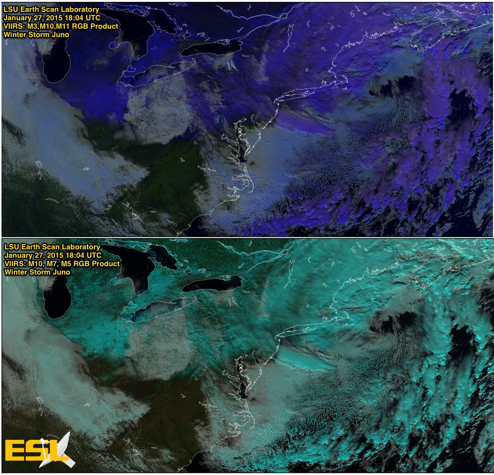
viirs_juno
Jan 21 2015 08 UTC NOAA-19 MRP SST
Tropical Cyclone Bansi
African Dust Storm
December 2014
Mexican Upwelling Image
2014 Christmas Image
Super Typhoon Hagupit
November 2014
Nov 28 2014 19:01 MODIS 250m LA
Cold Air Advection
Colorado Dust Storm
Nov 02 2014 08 UTC NOAA-19 Atch Bay SST
October 2014
Oct 27 2014 07:43 UTC AVHRR GOM SST
Hurricane Gonzalo Visible Eye
Hurricane Gonzalo Visible
MODIS Post Frontal Passage
Tropical Storm Gonzalo Water Vaport
Tropical Storm Gonzalo
September 2014
California Smoke Plume
Hurricane Edouard Atlantic
Hurricane Edouard
Hurricane Odile
August 2014
Gulf Disturbance
Hurricane Cristobal
Tropical Waves Atlantic Arrows
Eastern Pacific Hurricanes Iselle and Julio
Hurricane Bertha Water Vapor
Tropical Storm Bertha Dry Air
July 2014
Yosemite Fires
GOES-13 Dry Air
African Dust Stable Layer
Terra-1: Hurricane Arthur
Aqua-1: Tropical Storm Arthur
Tropical Storm Arthur
June 2014
African Dust
Hurricane Cristina June 12, 2014 SNPP Day/Night
June 4 2014 Mexico Fires
May 2014
Sumo-NPP Truecolor May 29, 2014 18:55 UTC
May 20 2014 GOES North Atlantic SST
VIIRS RGB Comparisons - San Diego Wildfires 2014
SNPP.20140513.0737.NPP
May 05 2014 08:01 UTC AVHRR GOM SST
April 2014
Suomi-NPP IR: Gulf Coast April 29, 2014 07:00 UTC
Apr 24 2014 NOAA 3 Day Composite
Suomi-NPP True Color April 9, 2014 19:31 UTC
March 2014
Mar 2014 GOES Monthly North Atlantic SST Anomaly
DNB Composite Northeastern United States
Suomi-NPP VIIRS Mid-IR Gulf Stream
Mar 04 2014 GOES Gulf SST
Mardi Gras Image
February 2014
Lake Superior Image with Ice
MODIS Image of Great Lakes Ice Cover
Suomi-NPP Swath February 10, 2014
Feb 10 2014 09 UTC NOAA-18 MRP SST
January 2014
MODIS Snow Image 2014
MODIS Image of Winter Storm
MODIS Heavy Sediment Annotation
NOAA-19 Eddy Image of the Week
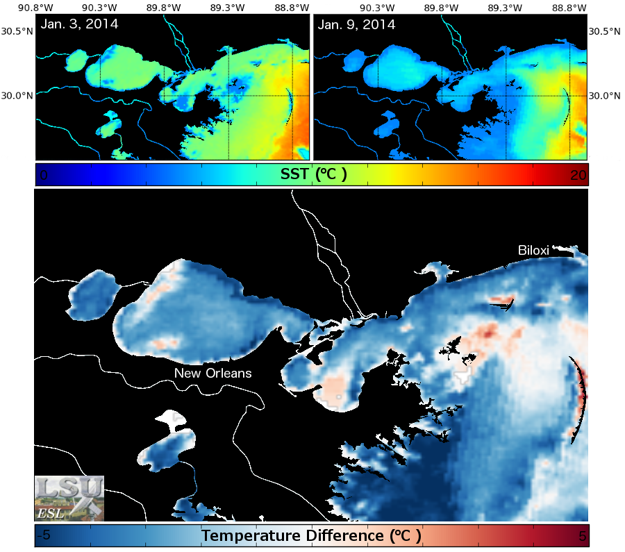
Jan 12 2014 19:05 MODIS 250m LA
AVHRR Cold Front SST
Jan 08 2014 19:30 MODIS 250m LA
December 2013
New Year Image 2014
GOES Weekly Composite Christmas Image
GOES Infrared December 6 2013 14:45 UTC
November 2013
Nov 27 2013 18:53 MODIS 250m LA
Nov 19 2013 GOES North Atlantic SST
Nov 12 2013 GOES North Atlantic SST
Nov 02 2013 18:59 MODIS 250m LA
October 2013
Happy Halloween!
Oct 08 2013 19:05 MODIS 250m LA
October 3, 2013: KAREN-2013 Visible over SST
September 2013
Sep 2013 GOES Monthly North Atlantic SST Anomaly
NOAA-130909-130923-FRONTAL PASS
Tropical Storm Ingrid
Sep 03 2013 GOES North Atlantic Storm Conditions
August 2013
Aug 2013 GOES Monthly Gulf of Mexico SST Anomaly
Hurricane Katrina - August 28, 2005 Anniversary
Fernand
MODIS Image of Sediment from Atchafalaya Basin
Invest 92L Forecast Models
Tropical Storm Erin Forecast Models
Aug 06 2013 GOES North Atlantic SST/SSH
July 2013
NOAA-19: Remnants of Tropical Storm Dorian
Tropical Storm Dorian's Forecast Track
Tropical Depression Dorian Models
g13.130716.weekcomp.sst.storm.iotw.jpg
Jul 02 2013 GOES North Atlantic SST
June 2013
NOAA-19 Visible Image of Tropical Storm Barry
June 5 2013 16:16 Tropical Storm Andrea Truecolor
t01.130605.1621.iotw.jpg
May 2013
n16.130514.1524.no_cloudmask.iotw.jpg
May 05 2013 17:09 MODIS TC SWATH
April 2013
Apr 30 2013 GOES North Atlantic SST
MODIS TRUECOLOR IOTW
GOES-13 Weekcomp Gulf Stream
Apr 09 2013 GOES North Atlantic SST
Apr 02 2013 GOES Gulf SST
March 2013
Mar 27 2013 16:52 MODIS 250m LA
Mar 26 2013 GOES North Atlantic SST
Mar 24 2013 20 UTC NOAA-18 Atch Bay Reflectance
Mar 19 2013 19:23 MODIS 250m LA
Mar 12 2013 19:17 MODIS 250m LA
Mar 03 2013 19:23 MODIS 250m LA
February 2013
Feb 26 2013 19:04 MODIS 250m LA
Feb 16 2013 16:46 MODIS 250m LA
January 2013
Jan 24 2013 16:40 MODIS 250m LA
Jan 17 2013 16:34 MODIS 250m LA
December 2012
Dec 22 2012 19:17 MODIS 250m LA
Dec 12 2012 16:58 MODIS 250m LA
November 2012
Nov 16 2012 16:21 MODIS 250m LA
October 2012
Oct 28 2012 19:10 MODIS 250m LA
September 2012
Sep 10 2012 19:10 MODIS 250m LA
Sep 07 2012 17:05 MODIS 250m LA
Sep 06 2012 19:31 MODIS 250m LA
July 2012
Jul 16 2012 16:40 MODIS 250m LA
June 2012
Jul 01 2012 GOES El Nino SST Color
Jun 04 2012 UTC Atlantic Basin SST
May 2012
May 17 2012 16:15 MODIS 250m LA
April 2012
Apr 09 2012 16:52 MODIS 250m LA
March 2012
Mar 24 2012 17:00 MODIS 250m ATCH
February 2012
Feb 29 2012 GOES GOM Color SST/SSH
Feb 08 2012 19:00 MODIS 250m LA
January 2012
Jan 28 2012 19:18 MODIS 250m LA
December 2011
Dec 22 2011 GOES GOM Color SST
Dec 01 2011 17:06 MODIS 250m LA
November 2011
Nov 17 2011 17:00 MODIS 250m LA
October 2011
Oct 15 2011 19:24 MODIS 250m LA
September 2011
Sep 27 2011 16:24 MODIS TC SWATH
Sep 13 2011 GOES North Atlantic SST
August 2011
Aug 30 2011 19:12 MODIS 250m MRP
Aug 15 2011 16:45 MODIS 250m LA
July 2011
Jul 30 2011 16:45 MODIS 250m LA
Jul 21 2011 GOES Color N. GOM SST
Jul 05 2011 16:55 MODIS 250m MRP
June 2011
Jun 29 2011 19:00 MODIS 250m LA
May 2011
May 28 2011 19:00 MODIS 250m PONTCH
May 18 2011 16:48 MODIS 250m LA
May 11 2011 16:42 MODIS 250m MRP
February 2011
Feb 11 2011 16:48 MODIS 250m LA
January 2011
Jan 27 2011 19:07 MODIS 250m ATCH
December 2010
Dec 28 2010 GOES North Atlantic SST
October 2010
Oct 14 2010 19:13 MODIS 250m ATCH
September 2010
Sep 08 2010 16:24 MODIS 250m LA
August 2010
Aug 01 2010 17:01 MODIS 250m LA
July 2010
Jul 29 2010 16:30 MODIS 250m LA
June 2010
June 27, 2010 23:52 SST/SAR of the DWH
May 2010
May 20, 2010 11:56 SST/SAR of the DWH
May 12, 2010 15:55 SST/SAR of the DWH
April 2010
Apr 25 2010 18:50 MODIS 250m MRP
Apr 21 2010 16:00 MODIS 250m MRP
March 2010
Mar 06 2010 19:02 MODIS 250m LA
August 2009
Aug 25 2009 GOES North Atlantic Storm Conditions
July 2009
Jul 07 2009 GOES North Atlantic Storm Conditions
June 2009
Jun 30 2009 GOES North Atlantic Storm Conditions
Jun 23 2009 GOES North Atlantic Storm Conditions
Jun 16 2009 GOES North Atlantic Storm Conditions
Jun 09 2009 GOES North Atlantic Storm Conditions
May 2009
May 12 2009 GOES North Atlantic Storm Conditions
March 2009
Mar 02 2009 18 UTC NOAA-18 MRP SST
February 2009
Feb 06 2009 19:11 MODIS 250m LA
January 2009
Jan 07 2009 18:58 MODIS 250m LA
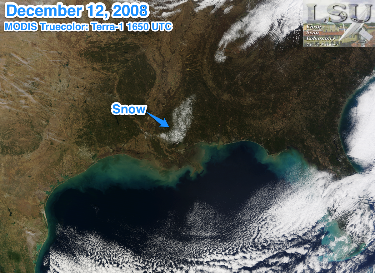
December 2008
MODIS TRUECOLOR SNOW IMAGE OF THE WEEK
November 2008
Nov 26 2008 11:17 UTC AVHRR GOM SST
October 2008
Oct 20 2008 16:24 MODIS 250m LA
September 2008
Hurricane Ike
May 2008
May 25 2008 16:49 MODIS 250m MRP
January 2008
Jan 01 2008 18:01 UTC OCM MRP Truecolor
Jan 01 2008 18:01 UTC OCM ATCH Truecolor
August 2007
Aug 28 2007 GOES North Atlantic SST
July 2007
Jul 17 2007 18:01 UTC OCM LA Truecolor
Jul 11 2007 19:06 MODIS 250m LA
Jul 01 2007 18:01 UTC OCM Extended GOM Chlorophyll
June 2007
Jun 26 2007 GOES North Atlantic SST/SSH
Jun 03 2007 18:01 UTC OCM GOM Chlorophyll
May 2007
May 25 2007 16:36 MODIS 250m ATCH
May 18 2007 18:01 UTC OCM GOM Truecolor
May 08 2007 19:06 MODIS 250m LA
April 2007
Apr 26 2007 18:01 UTC OCM GOM Chlorophyll
Apr 10 2007 GOES North Atlantic SST/SSH
March 2007
Mar 31 2007 16:23 UTC AVHRR Swath
Mar 05 2007 19:07 MODIS 250m LA
February 2007
Feb 28 2007 04 UTC NOAA-17 MRP SST
Feb 06 2007 GOES North Atlantic SST
January 2007
Jan 29 2007 04 UTC NOAA-17 MRP SST
Jan 02 2007 GOES North Atlantic SST
December 2006
Dec 02 2006 16:23 MODIS 250m LA
November 2006
Nov 25 2006 GOES GOM Color SST/SSH
Nov 14 2006 GOES North Atlantic SST
October 2006
Oct 24 2006 18:01 UTC OCM GOM Chlorophyll
Oct 03 2006 GOES North Atlantic Storm Conditions
September 2006
Sep 26 2006 19:06 MODIS 250m LA
Sep 16 2006 18:01 UTC OCM GOM Chlorophyll
August 2006
Aug 16 2006 19:12 MODIS 250m LA
July 2006
Jul 11 2006 GOES North Atlantic Storm Conditions
June 2006
Jun 20 2006 GOES North Atlantic SST
Jun 08 2006 18:03 UTC OCM GOM Chlorophyll
May 2006
May 23 2006 18:52 MODIS 250m LA
May 17 2006 07:32 UTC AVHRR Swath
April 2006
Apr 09 2006 18:03 UTC OCM GOM Truecolor
Apr 01 2006 18:03 UTC OCM GOM Chlorophyll
August 2005
Aug 10 2005 18:03 UTC OCM LA Truecolor
Aug 09 2005 GOES North Atlantic SST
June 2005
Jun 14 2005 GOES GOM Color SST/SSH
May 2005
May 25 2005 04:04 UTC AVHRR GOM SST
April 2005
Apr 28 2005 18:03 UTC OCM GOM Chlorophyll
Apr 05 2005 GOES North Atlantic SST
September 2004
Hurricane Ivan
October 2002
Hurricane Lili
August 1992
Hurricane Andrew Track
Hurricane Andrew Swath
Follow @earthscanlab

