
High Resolution Coastal Flood Mapping
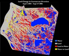
Hurricane-induced storm surges, waves, and rain can all contribute to widespread coastal flooding, particularly in low relief areas such as southeast Louisiana. Synthetic Aperture Radar (SAR) data provides measurements that can be used to map flooding. The SAR imagery is unaffected by cloud cover and is usable both day and night. In 2002, we began collaborating with researchers at NOAA NESDIS Camp Springs, MD. (through the ADRO II project) and gained access to SAR images of coastal Louisiana during the two week episode when Tropical Storm Isidore and Hurricane Lili impacted coastal Louisiana's water levels. Subsequently, SAR imagery and SPOT multi-spectral imagery were employed in the study of coastal flooding from Hurricane Katrina. Results were published in (Kiage et al., 2005). Funding for this research was provided mainly by the Louisiana Board of Regents.
Publications

Classification of southeast Louisiana 1987

Classification of southeast Louisiana 2004

Classification of southeast Louisiana 2005

Classification of southeast Louisiana 2006

Classification of southeast Louisiana 2010

Classification of southeast Louisiana in 2011

Total land change in the Chandeleur islands from 1997 to 2011
